Mild weather moves in across Corn Belt
Posted on January 13, 2026 by Greg Soulje
Source: Farm Progress. The original article is posted here.

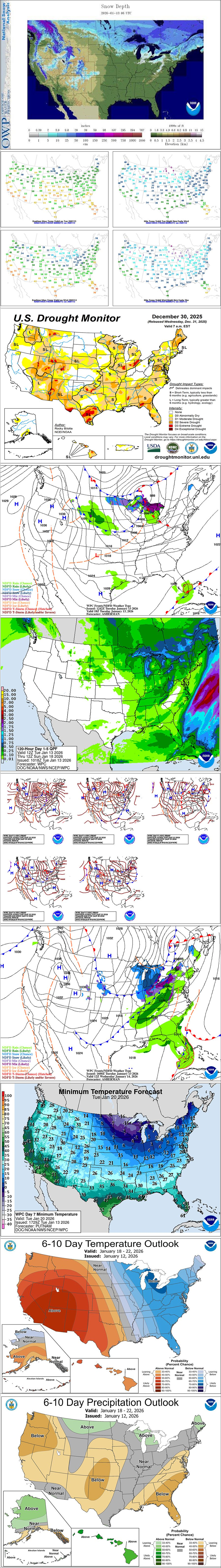
Across the Corn Belt, mild air is temporarily replacing previously cool conditions, while light precipitation—a mix of rain and wet snow—is traversing the Great Lakes states. Tuesday’s high temperatures should range from near 35°F in the upper Great Lakes region to around 65°F in the middle Mississippi Valley. Midwestern snow coverage has again largely retreated and is generally confined to areas from eastern North Dakota into the upper Great Lakes region.
On the Plains, downslope winds have contributed to significantly above-normal temperatures across the northern half of the region, despite widespread cloudiness. Tuesday’s high temperatures will reach 60°F or higher in parts of central Montana. Meanwhile, mild, dry weather also prevails across the southern half of the Plains, where topsoil moisture has been locally boosted (especially in southeastern Colorado and neighboring areas) by the melting of last week’s snowfall.
In the South, light but beneficial rain has spread across some drought-affected areas in southern Texas. A few showers are also occurring in southern Florida. Cool, dry weather covers the remainder of the region. In the Southeast, freezes were noted Tuesday morning as far south as the panhandle of Florida.
In the West, air stagnation and foggy conditions linger in parts of the Northwest and across California’s Central Valley. Except in areas experiencing fog and low clouds, above-normal temperatures prevail. Current snow-water equivalency is less than 50% of the mid-January average in much of Oregon, far northern sections of California and Nevada, and portions of the Four Corners States, highlighting the preponderance of this winter’s warm, rainy Western storms.
Related: Schumer urges Rollins to block Tyson beef plant closure
During the next 5 days, any precipitation will be generally light and confined to the central and eastern U.S., as warm, dry weather will dominate the West.
Regarding storminess, a series of disturbances traversing the northern Plains, Midwest and Northeast will generate periods of precipitation. Some of the most significant snow will fall downwind of the Great Lakes. Portions of the central and northern Appalachians may also receive significant snow, especially from Wednesday into Thursday.
Occasional rain showers will affect the South, although most areas will receive less than an inch during the next 5 days.
The disturbances will draw progressively colder air across areas east of the Rockies, with widespread sub-0°F temperatures expected by the weekend across the upper Midwest.
Looking ahead, the 6- to 10-day outlook calls for the likelihood of below-normal temperatures from the Mississippi River to the Atlantic Coast, while warmer-than-normal weather will prevail in most areas from the Pacific Coast to the Plains.
Related: U.S. red meat demand strong, despite tight supplies, trade issues
Meanwhile, near- or below-normal precipitation across most of the country should contrast with wetter-than-normal weather across portions of the nation’s northern tier, mainly from Montana to Maine.

Clark County Feeders is a BQA Certified 655-acre feed yard and grain storage facility specializing in beef cattle custom feeding and grain purchase, storage and sales.
.jpg?disable=upscale&width=1200&height=630&fit=crop)